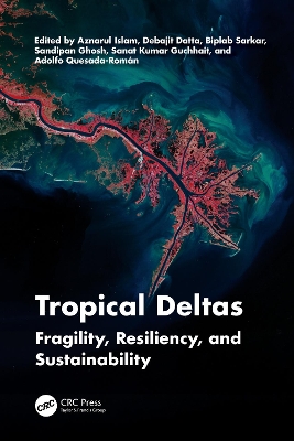
Tropical deltas of the world are in decline and are threatened by climate change, geo-environmental dynamics, natural hazards, and disasters. This book is a comprehensive discussion of the present delta crisis and the various risks the deltas are facing due to human and natural factors. It addresses their resilience, the importance of biodiversity, and the future adaptations for sustainable management of tropical deltas. The use of geospatial tools for the assessment and modeling of environmental degradations and the applications of AI and ML are examined in 22 chapters, from different major deltas of the world, to help readers understand the interdisciplinary perspective of deltas’ vulnerability and sustainability. Features Provides comprehensive coverage of global tropical deltas, their physical environment, hazard profiles, and socio-economic threats in a changing climate. Includes research-based discussions blended with global case studies to demonstrate the status of deltas around the world and the status of field-based investigations. Offers a holistic understanding of multifaceted dimensions of delta crises due to changes in landscape ecology, and the impact of various natural and man-made hazards. Addresses the critical challenges of sustainable management using a modelling approach with spatial maps and geostatistical diagrams. Discusses perspectives of restoring delta systems around the globe for solving environmental and societal problems. This reference book is for researchers, academics, graduate, and senior undergraduate students in Geography, Geomorphology, Hydrology, Regional Planning, Environmental Science, Ecology, and Engineering, and those interested in water conservation and sustainability, including professionals in industry and government, and human rights activists.
Author Biography
Aznarul Islam (b. 1987) completed his Master of Science in Geography from Kalyani University, West Bengal and MPhil and PhD in Geography from the University of Burdwan, West Bengal, India. He has been an Assistant Professor in the Department of Geography, Aliah University (AU), Kolkata, India since 2016 and served as the HoD (off.), Geography, AU from November 2019 to February 2022. Previously he was an Assistant Professor (West Bengal Education Service) at the Department of Geography, Barasat Government College, West Bengal (2014– 2016). Dr. Islam served as Guest Faculty/visiting faculty in a few institutes such as Jadavpur University, Kolkata, and Kazi Nazrul University, Asansol. He was awarded the UGC Junior Research Fellowship in Geography in 2012. He also secured All India Rank 018/188 in Earth Sciences in CSIR-UGC NET in 2011. He has already published more than 80 research papers including 50 SCI journal articles. He edited another 10 books and contributed more than 26 book chapters in edited volumes and conference proceedings. He has presented papers in more than 35 national and international seminars and conferences. He has successfully guided three PhD theses; one thesis submitted and two theses under preparation. He was awarded one UGC minor research project. He completed one major research project funded by the ICSSR, Govt. of India in 2019 as the sole Project Director. He received a Department of Science and Technology (Government of India)- Science and Engineering Research Board (DST- SERB) State University Research Excellence (SURE) Award in 2023 as the Principal Investigator. He has been performing the role of editor and reviewer in various journals published by reputed academic publishers. He is a life member of the Indian Geographical Foundation (IGF), Kolkata, and the National Association of Geographers, India (NAGI), New Delhi. His principal area of research includes exploring river, water, and society through the lens of applied spatial sciences using quantitative techniques and geo-informatics for reducing fluvial and hydrological hazards to enhance community relicense. Debajit Datta (b. 1982) is an Associate Professor of Geography at Jadavpur University, Kolkata, India. He specializes in landscape ecology and environmental geography. He obtained his BSc (Presidency College, Kolkata) in 2004 and MSc (University of Calcutta) in Geography in 2006. He was awarded a PhD in 2012 from the Indian Institute of Technology, Kharagpur. He has extensively worked on the management of coastal and forest ecosystems of eastern India, potentials of ecotourism development, and sustainable livelihood generation of indigenous communities for the last 16 years. At present, his prime research interests include blue carbon mapping, political ecology of common property resources, assessment of agroecosystem sustainability, and socio-ecological transformations of coastal landscapes. He has published more than 60 research papers and scientific articles in peer- reviewed journals, edited book volumes, and periodicals. He was awarded research fellowships by the Council of Scientific and Industrial Research and University Grants Commission (UGC), India. He has conducted several research projects funded by the UGC, RUSA- JU, STARS- 2 of Government of India (GoI), Department of Science and Technology (DST) of GoI (Mentor Scientist), and Science and Engineering Research Board (SERB) of DST- India. He serves as a Board Member and the Regional Contact for South Asia of the Young Geographer Working Group of the Asian Geographical Association. He is also the Regional Coordinator of Eastern India for the Indian Regional Association for Landscape Ecology (2022– 2024). At present, he is on the editorial boards of several international and national peer- reviewed journals. Biplab Sarkar did his MA in Geography at the University of Kalyani and obtained his PhD in Geography, Aliah University, Kolkata, India in 2021. His PhD thesis was titled as Decaying of River Churni and Its Impact on Ecology, Economy and Society. His main research interests include fluvial geomorphology, environmental geography, surface and groundwater hydrochemistry, hazard and disaster management. Sandipan Ghosh is an Applied Geographer with a Post- Graduate, MPhil and PhD in Geography from The University of Burdwan. He has published more than thirty international and national research papers in various renowned journals of geography and geo-sciences. He has worked with several reputed academic publishers, as both author and editor. He has also worked as a reviewer in many international geo-science journals, including Taylor & Francis (Geo-Carto International). Ghosh is a lifetime member of The International Association of Hydrological Sciences (IAHS), Eastern Geographical Society (EGS), and Indian Geographical Foundation (IGF). His principal research fields are various dimensions of fluvial geomorphology, flood geomorphology, Quaternary geology, and laterite study. Currently, he has worked on the gully geomorphology and soil erosion on the lateritic terrain of West Bengal and the Quaternary geology and active tectonics of Lower Damodar Basin, West Bengal. At present, he is an Assistant Professor in the Department of Geography, Chandrapur College, Barddhaman, West Bengal. Sanat Kumar Guchhait (b. 1968) completed his MSc (Geography) in 1993 and PhD in 2005 from the Department of Geography, University of Burdwan. Prof. Guchhait is currently engaged in teaching in the Department of Geography, University of Burdwan, West Bengal, India, since 2001. His areas of interest are environmental geography, social geography, and philosophy of geography. In conducting research and writing books, he prefers to enquire about the tune of environment, society, and livelihood. For the last ten years, his research has focused on the environment and the forest, enclave exchange, traditional livelihood, and ecological knowledge of tribal society.. He has completed a UGC Major Research Project on soil erosion, conservation, and forest ecology in laterite landscape. He has successfully supervised 11 doctoral students and published 65 research papers in different peer-reviewed national and international journals and edited books. Adolfo Quesada-Román has a broad trajectory working with local and national governments, international NGOs, private companies, research institutes, and universities worldwide, focusing on disaster risk management, cartography and geospatial analysis, environmental impact studies, and natural resource management. His specialization covers several areas, with a focus on geomorphology, geomorphic cartography, natural hazard zoning, land use planning, physical and environmental geography, climatology, dendrochronology, and geoheritage. He has an extensive academic output, with over 100 indexed publications in these fields.


Reviews
There are no reviews yet.