
We ship worldwide - see checkout for options
Exceptional customer service trusted by 100's
£9.95
We ship worldwide - see checkout for options
Exceptional customer service trusted by 100's
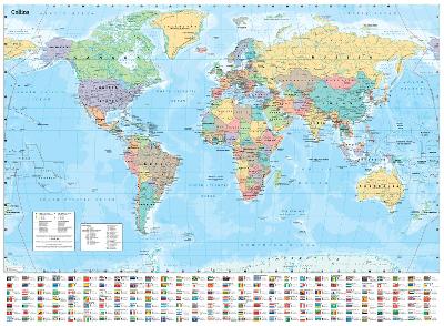
Explore the world with a Collins wall map Fully updated world map to include the latest political changes. The map contains politically coloured mapping which shows each country and their capital city, major roads, and cities and towns clearly. Also included are national flags, key statistics for every country and inset maps of the polar regions. The map is printed on high quality paper and comes rolled in a fully recyclable cardboard box – ideal as a poster for any classroom, bedroom or office wall. Area of coverage: All of the world, centred on the Greenwich Meridian, and including maps of the North and South Pole regions. Scale: 1:30 000 000; 1 cm to 300 km; 1 inch to 480 miles Size: 700 x 915 mm (27.5 x 36 inches) Other versions available: Laminated flat map (ISBN 978-0-00-849254-0)
| Weight | 0.27 kg |
|---|---|
| Author | |
| Editor | |
| Photographer | |
| Format | |
| Illustrators | |
| Publisher |
Only logged in customers who have purchased this product may leave a review.

Paperback
Original price was: £12.95.£8.95Current price is: £8.95.In Stock


Paperback
£3.50 CD-ROM
£19.95 Paperback
£5.95 Paperback
£4.00
Hardback
Original price was: £34.95.£29.95Current price is: £29.95.
Paperback / softback
£17.95
Reviews
There are no reviews yet.